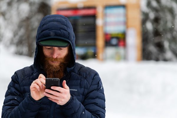
Your phone has become the ultimate backcountry resource, but should you let it make all your decisions?
If we’re going to do this, we need to follow the rules.” Chris Rubens admonishes me for taking the easy way around while he sidesteps across running water for the third time in less than a kilometre. There’s a perfectly good skin track within sight, but Rubens is here to judge this challenge, and he’s taking it seriously. The challenge is simple: to see if the technology in my phone can lead us to a better day of skiing than the ultimate local guide.
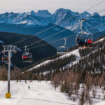
Rogers Pass is the most famed ski touring location in Canada, and in The Pass, Greg Hill is our team’s ultimate local. Hill has been skiing here for 22 years, and he tours a lot. He once racked up two-million vertical feet in a year (I know this is Canada, but it sounds bigger than 609,600 metres). Hill is also a certified ski guide, so he should have known better than to let my phone guide us through hazardous mountains. Still, he was willing to play the fool to see how this experiment would pan out. Would he find a new favourite run or end up lost? Could a phone full of crowdsourced apps lead us to the goods, or would we walk right into trouble and be followed by dozens of other digital lemmings?
A province away, I fired up my phone. I hadn’t skied Rogers Pass in more than a year, but social media had been constantly reminding me of how great it was. That day, in fact, I read a Facebook report bragging about deep powder in the Loop Brook drainage (south-central Rogers Pass). That was all the recommendation I needed.
The Mountain Information Network App enticed me further with a pin dropped on a popular area of Loop Brook called Bonnie Trees: “Feb. 28, Riding quality: GOOD; Snow conditions: POWDER; We rode: Alpine slopes–Steep slopes–Open trees.” I bought it all.
Google Earth allowed me to fly through the mountains and get an impression of the zone. With FatMap’s 3D winter map and its “slope angle” filter, I could see how steep the skiing was going to be. The “avalanche terrain” filter confirmed that we’d be in danger at times, so I went hunting for a conservative route to follow.
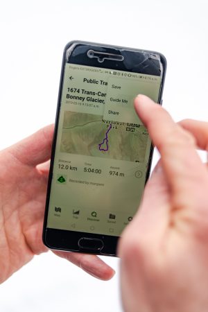
Gaia GPS had a “public tracks” overlay that showed a spaghetti dish of intertwined routes tangling their way across the Bonnie Trees. I searched for the most efficient, fun and safest. But in the end, I chose “Bonnie with Ardelle” because there was something comforting about a person’s name instead of the generic “Track 03” or “Tour to Bonnie.” Ardelle sounded trustworthy.
While Google Maps guided my truck in the pre-dawn, Hill called to discuss conditions. He joked that he was already up touring a mountain near Revelstoke by headlamp but that he’d have no trouble meeting us in Rogers Pass by 8:00 a.m. He’d downloaded the overnight weather data and read it to me, “Mt. Fidelity temps were -4 to -6 Celsius. Winds reached 93 km per hour. Nine cm of new snow.”
The daily avalanche forecast webpage updated just before we met. Good and bad news: “extreme winds at ridgetop overnight have created considerable avalanche danger in the alpine,” but also, “sheltered storm snow has settled to 20 cm of soft powder.” At the trailhead, we resolved to stick to safer terrain, and Hill started his watch to record our day, but I stepped in front and hit “Guide Me” on the GPS. Ardelle would take it from here.
That’s how Rubens ends up straddling the creek, risking an icy swim, while imploring us to stick to the rules of the challenge. Under his breath, he adds, “So far, Ardelle has done a good job of going exactly where I wouldn’t.”
Soon the valley tightens, and all tracks, both physical and virtual, converge. As we enter a clearing, I notice Hill staring up, analyzing the steep face of Ross Peak. Rubens has spaced out behind me. I’m no dummy (though I play one for this experiment), so I double-check FatMap’s Avalanche Terrain map. There’s no danger warning, and I really want to believe it, but what else could have taken out all these trees? The judges in my brain say: Score one for human decision-making.
I could tour faster with two poles pushing and my eyes on the trail, but I need to hold the phone. I drop a pin on the SpotWx map and get an up-to-the-moment, location-specific weather forecast, hoping more information will make us safer. “Cloudy with sunny periods. Isolated flurries. Wind SW 20-40 km/h.” So…pretty much a 50 per cent chance of anything.
Half an hour later, we reach a decision point where the two common skin tracks diverge. One heads east, arcing around steeper slopes, while the other points straight up. Hill has pulled over to wait. “Does Ardelle go upright or swing around left?” he asks. I tell him that she’s kind of gone in-between. He looks sceptically over my shoulder at the phone, “Hmmm.” Questing into the dense forest to break a third trail seems silly, but rules are rules, and today we follow Ardelle!
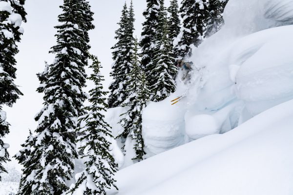
I sweat but try to look casual while breaking trail in knee-deep snow and, like a lantern in a coal mine, hold the phone ahead of me. There are places I want to angle above trees or cut back, but I resist all instinct and follow the blue line on my screen. Almost without fail, Ardelle makes turns we would not have. And almost without fail, they end up being great moves that lead us to friendly ground. “Ardelle has been nailing the little terrain features,” Hill notes. Score one for technology.
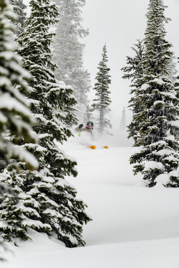
As we climb out of the forest, the world turns grey and uninviting. With one bar of cell reception, we check The Weather Network. The radar shows a clear patch floating our way, so Greg convinces us to rip skins and ski the glades below, then hitch back onto the track we’d established. With any luck, the weather will be better when we return. Of course, this is entirely outside the rules, but the skiing looks too good to pass up, so we put the digital guides away and follow the local one.
The snow is even better than the Mountain Information Network let on (but, of course, not as good as social media made us believe). We blast off powdery bumps and weave around snow-covered trees, just following our ski tips and our whim. The improvisation is freeing, and no one cares where it’s leading. Out of breath at the bottom, I ask Hill if he’s ever skied this hidden secret run that Ardelle led us to? “Yeah. Not very often, though. Maybe five times.”
Above treeline, we follow Ardelle’s GPS track again, but my phone battery is getting low. She (I imagine Ardelle as a she; Rubens envisions a big burly dude) takes us higher to the west, and Hill gets excited. A favourite line of his is over this way. As we approach her high point, my phone dies, and I’m distraught. How can we get home without the apps I’ve been staring at all day? I’ve become dependent on the blue dot that shows my precise location on the planet at all times.
Hill suggests we climb to a run that’s longer and track-free. Lost without the GPS, I give in. I long for Ardelle’s guidance, but Hill knows the area pretty well, I assure myself. He’s skied this drainage more than 100 times, and the slope above us is called 2 Mill Hill in his honour, for whatever that’s worth.
The views are stunning—now that I’m not staring at my screen.
We tour below Bonnie Glacier, whose crevasses are easily seen on FatMap, but lie hidden by the winter’s snowpack today. Hill marches us along a sharp ridge for 200 metres until we stand atop a dream run with no tracks in sight. Maybe there are some advantages to local knowledge after all? Score 2-1 for the humans.
The 600-metre descent consists of expansive, rolling lefts and rights that funnel into short drainages before opening again and allowing mellow cruising to valley bottom. We let Hill ski first and follow his track. Skiing is easier when you’re not staring at a GPS screen. 3-1.
Back at the truck, our gadgetry tells us it was a 2,000-vertical-metre day, but my legs say it was more. Later I’ll upload pictures to Instagram to show-off (bonus point technology), but first I check the Suunto App and see that Hill hadn’t been joking at all. He really had woken at 4:30 a.m. and ski-toured 1,500 vertical metres before he met up with us. Point and match goes to Greg Hill.
But by the following day, I’ve bought an app that promises me superior fitness, and I see on Gaia that a new party has already followed our track up Loop Brook. The ultimate local has won this round, but armed with modern tech we’re all closing the gap, if only slightly.
4 APPS
Ski Tracks is the most popular ski-tracking app, but check out Slopes. It can break down the usual ski stats (vertical, runs, speed, distance) to show each run individually, but it also shows others who have skied those runs, how fast they’ve gone and if they’re friends of yours. For bragging purposes, you can see friends’ stats and upload to Strava.
FatMap is invaluable for backcountry skiers, with clear terrain images to help you navigate and plan your trip. But it also features ski resorts by laying runs over its 3D mountain maps. Tap any run for its characteristics and slope profile, or scroll through runs to find the one you want to ski next. Of course, it can also record your day and the Discover tab highlights recent activity in your area.
Snow-Forecast breaks down a skier’s three main weather concerns (temperature, wind, precipitation) into three different elevation bands. It also offers weather maps, has links to webcams and you can set up snow alerts, so you never miss a powder day.
Gaia GPS is a popular and user-friendly GPS app with several different maps or satellite images. It tracks your progress reliably, doesn’t chew up your battery life and easily imports GPX tracks that you find online or get from friends.